Hyperspectral imaging is a powerful, non-destructive method for detection, analysis and mapping of minerals, both in the field and in the lab. It captures unique spectral signatures enabling highly accurate mineral differentiation, detection of hydrothermal alterations, and evaluation of ore potential with unmatched precision.
From airborne surveys to core sample and tailings analysis, hyperspectral imaging is an ideal tool for accurate and efficient geological mapping, mineral identification, and mining operations.
Accurate Mineral Identification: Distinguish and map minerals based on their unique spectral signatures, enabling precise identification of alteration minerals associated with oil, gas, and ore deposits.
Improved Exploration Targeting: Detect surface geochemical indicators and alteration zones that guide geologists to high-potential exploration targets, reducing uncertainty in early-stage exploration.
Non-Destructive Analysis: Analyze geological formations without disturbing the environment or sample, supporting sustainable exploration practices and regulatory compliance.
Enhanced Geological Mapping: Generate detailed mineralogical and lithological maps that improve understanding of subsurface structures and depositional environments.
Early Risk Reduction: Identify unfavorable zones early in the exploration process, allowing teams to focus resources on the most promising prospects.
Remote and Hazardous Area Access: Enable exploration in regions that are difficult, dangerous, or costly to access on the ground, improving safety and operational efficiency.
DrillCoreAnalysis&Logging
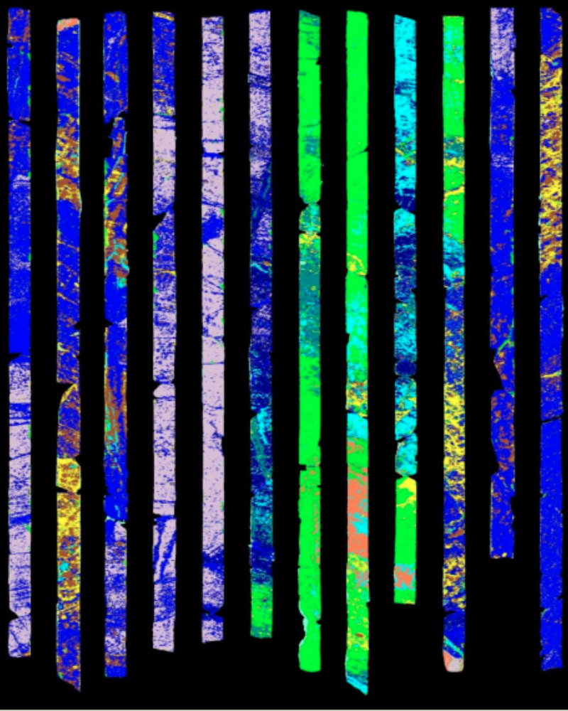
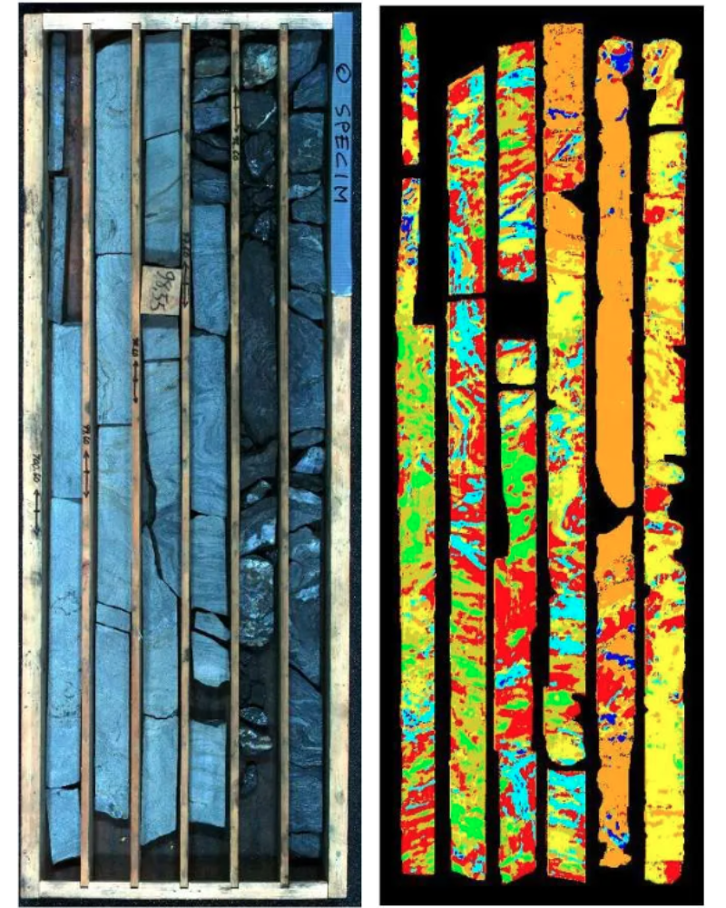
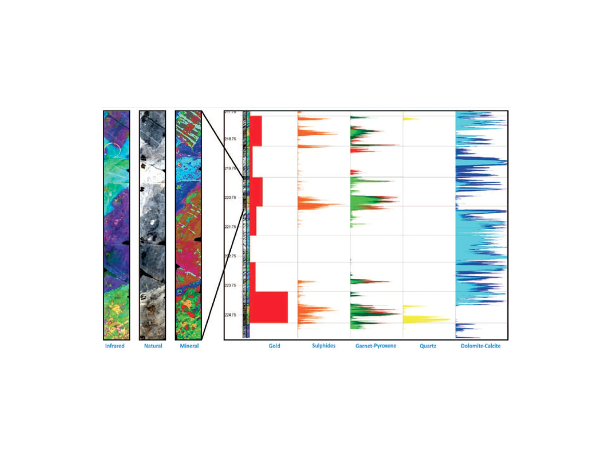
Hyperspectral drill core analysis and logging is a powerful upgrade to traditional geological logging in mining, mineral exploration and tailings reprocessing. It delivers high-resolution spectral data as well as spatial information to automatically identify minerals, alteration zones and geochemical proxies along drill core.
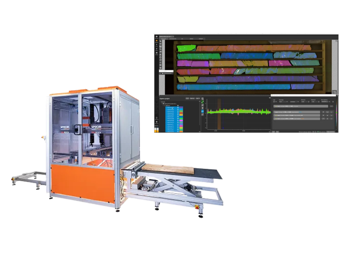
The Specim SisuROCK workstation has become a market-leading tool for analytical service providers, national geological surveys, and mining companies to rapidly image entire core boxes and process large volumes of core quickly and efficiently.
The SisuROCK integrates multiple Specim state-of-the-art hyperspectral cameras, from visual to thermal range, including the RGB and 3D imaging options and double-sided illumination for optimized image quality. Featuring fully automated core logging capabilities, and entire core box can be imaged in seconds, eliminating the need for time consuming sample preparation. It delivers excellent spatial and spectral resolution, and is designed and proven to improve efficiency and productivity of drill core analysis and mineral mapping.
MineralExploration&Mapping
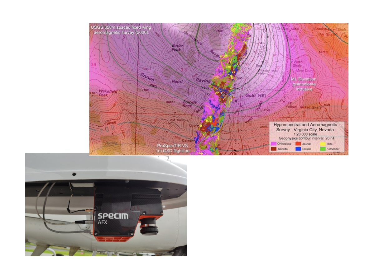
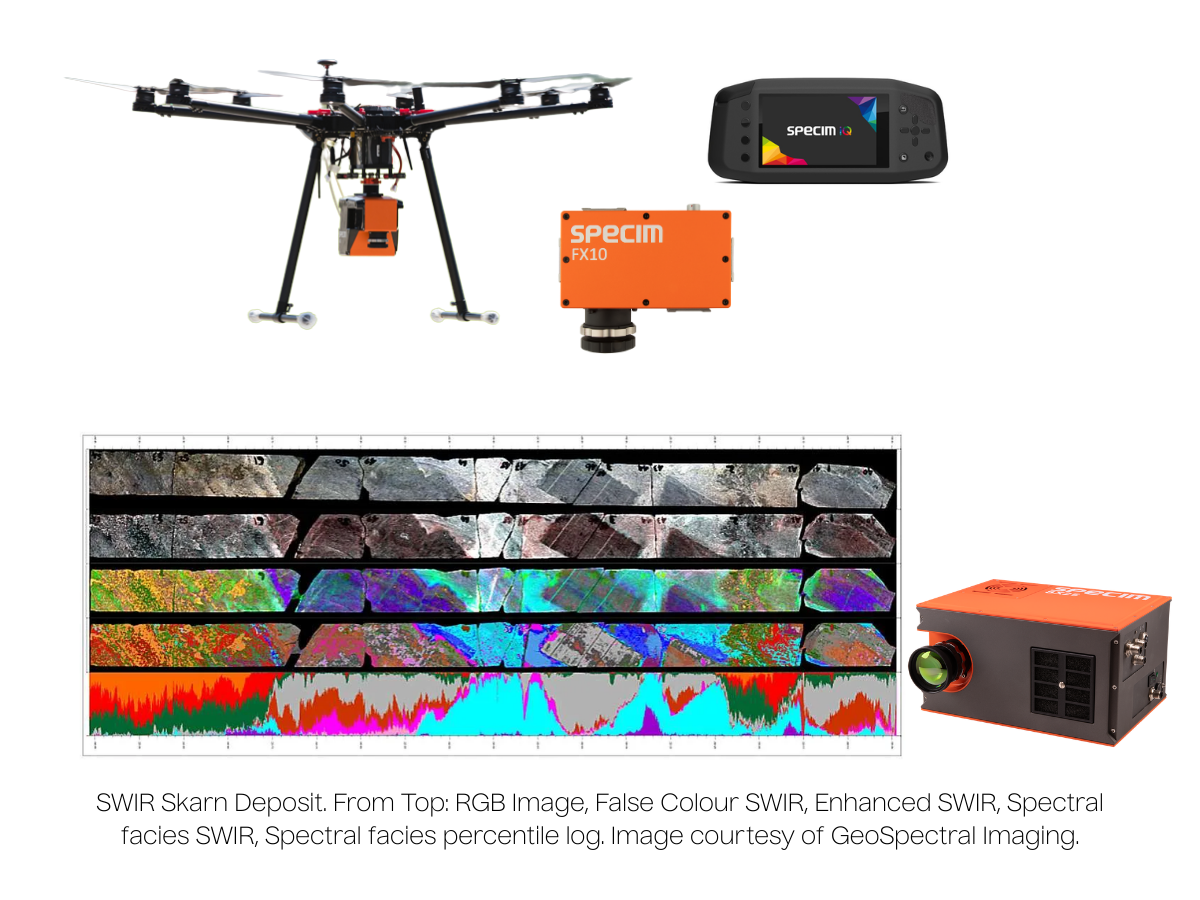
Hyperspectral cameras are increasingly popular not only for efficient core logging, but also at mining sites and on processing lines, and can be used to image entire mine wall faces on ground vehicles, or large areas via drones for rapid mineralogical mapping.
Hyperspectral imaging allows for mapping of clays, talc and other deleterious rock phases, producing valuable information for building predictive models of mining and geometallurgical parameters.
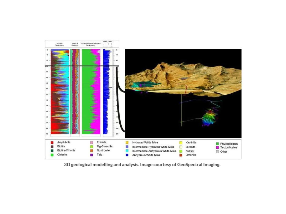
HSI provides detailed, quantitative mineral maps that help identify alteration zones, track fluid pathways, and guide drilling decisions based on spectral mineralogy. Through airborne imaging, it also enables exploration of remote and hazardous areas that otherwise can be difficult or impossible to access, improving both safety and operational efficiency.
IronOxideMineralsandRareEarthElementDetection
Iron oxide minerals are essential in mineral exploration as they are often the only visible clues to underlying mineral deposits. Iron oxide minerals have a characteristic spectral feature in the 800-1000nm wavelength range, allowing them to be accurately detected by UAV optimized systems such as the Specim AFX10 and AFX17.
Iron oxide concentrations are associated with specific types of 'host rocks', which are sometimes indicative of potential ore deposits. Hyperspectral imaging can be used to classify iron oxide concentrations based on host rock substrates, increasing the potential to identify rock outcrops most likely associated with ore deposits.
Rare Earth Elements (REEs) are a group of metallic elements that are indispensable for the manufacturing of high-technology products, including consumer electronics. These elements occur in particular minerals and can be identified with hyperspectral imaging technology due to their key spectral features in the VNIR wavelength range. This makes hyperspectral remote sensing a ground-breaking tool for the exploration of economic concentrations of REE-bearing minerals.
The Visible and Near-Infrared (VNIR) range, spanning 400nm to 1000nm, is ideal for mapping iron oxides (hematite, geothite), vegetation and oxidation zones. High-quality VNIR cameras, such as the Specim IQ, FX10 and AFX10, are particularly useful for early-stage alteration detection and preliminary rare-earth element (REE) studies.
SWIR (1000-2500 nm)
The Short-wave Infrared (SWIR) range is the most widely used range in mineral exploration and is critical for detecting clays, carbonates, and hydrothermal alteration. High-resolution SWIR cameras, such as the Specim SWIR and SX25, are especially useful for porphyry, epithermal and sediment-hosted systems.
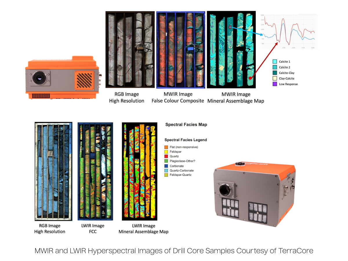
The Mid-wave Infrared (MWIR) range, spanning from 2.7 to 5.3 µm, is used to detect hydrated minerals and hydrocarbons, expanding the range of geological and environmental applications. The Specim FX50 is an excellent tool for calcite and dolomite identification.
LWIR (7.7 - 12.3 µm)
Long-wave Infrared (LWIR) hyperspectral cameras, such as the FX120 which covers 7.7 to 12.3 µm, capture emissivity-based data for silicates like quartz and feldspars, enabling lithological discrimination and mapping of major rock-forming minerals.
InfraredMineralIdentificationTable
This infrared mineral identification table summarizes which range of the infrared spectrum (VNIR, SWIR, MWIR, LWIR) are most effective for identifying different mineral groups.
This infrared mineral identification table was generated by TerraCore.